You Won’t Believe What People Have Found on Google Earth
People zoom in on Google Earth expecting cities or roads, but sometimes the satellite images show stuff you’d never expect, including optical illusions, giant logos, and symbols carved into the earth. Let’s check out some strange and hilarious things just sitting out in the open.
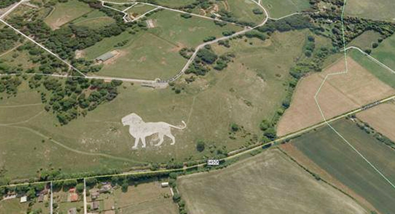
Lion King – 51.848637, -0.55462 (Dunstable LU6 2LD, UK)
Credit: Facebook
Right in the middle of a green field near Dunstable Downs, someone etched a massive chalk figure of Simba from “The Lion King.” It’s part of a promotional campaign by Disney, stretching over 150 feet across. Locals were stunned when it showed up, visible even from the sky.
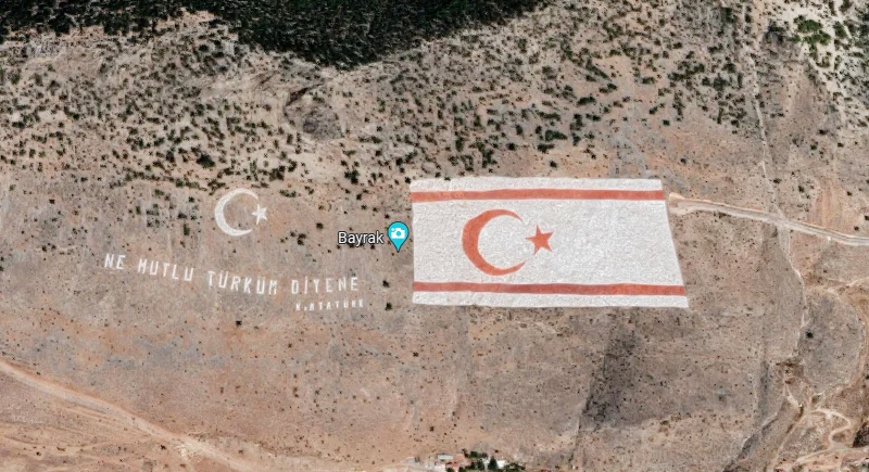
Northern Cyprus Flag – 35.282902, 33.376891 (Kyrenia, Cyprus)
Credit: Reddit
On the side of the Kyrenia mountains, a Turkish Cypriot flag stretches across the rocks, painted straight onto the mountain face. It’s huge, about 1,640 feet wide, and includes the Turkish national motto in bright white.
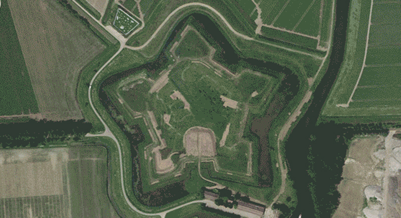
Star Fort – Schansdijk 5, 4655 De Heen, The Netherlands
Credit: Reddit
From above, Fort Bourtange looks like a perfect star-shaped pattern. It was built in the late 1500s to defend against Spanish forces. The sharp geometric design wasn’t obvious until satellites captured the full view. It’s now a museum town that attracts visitors who originally saw it on Google Earth.
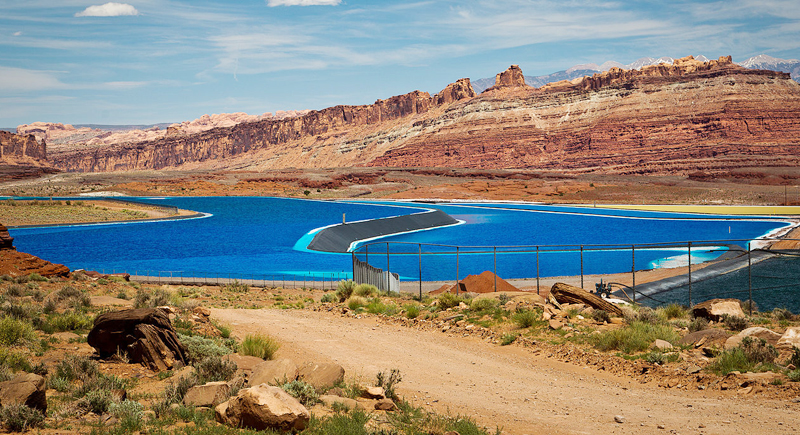
Potash Ponds – 38°29’0.16″N 109°40’52.80″W (Moab, Utah, USA)
Credit: Wikimedia Commons
These insanely blue pools in the middle of the Red Rock Desert are potash evaporation ponds. The color comes from dye added to speed up solar evaporation. They collect potassium chloride for fertilizer, and their color contrast is so sharp that people thought it was edited, until they looked it up.
Mysterious Pattern – 37.629562, -116.849556 (Nevada, USA)
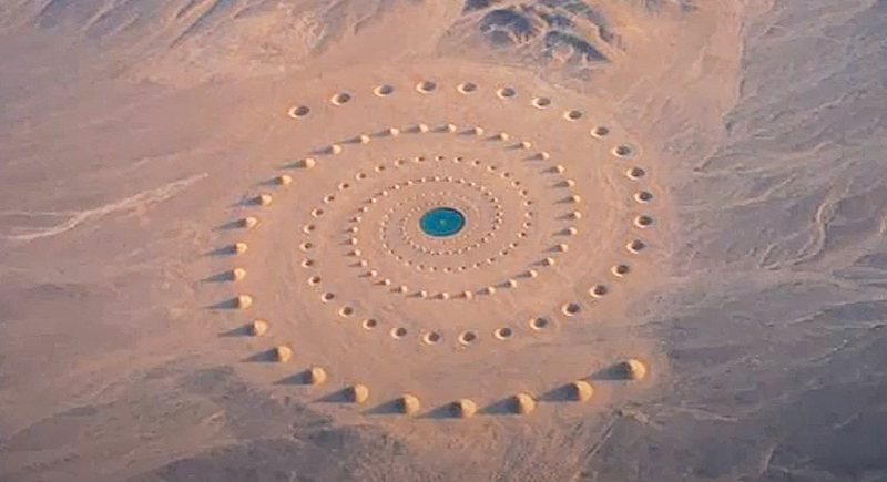
Credit: Youtube
Spotted near the Tonopah Test Range, this strange triple-circle pattern stirred up plenty of theories, UFO landing site, secret base, or just a target for testing aircraft sensors. It’s still unclear who made it, but it appears to be on government-controlled land.
The Whampoa Boat-Shaped Shopping Centre – 22°18’14.15″N, 114°11’24.66″E (Hung Hom, Kowloon, Hong Kong)
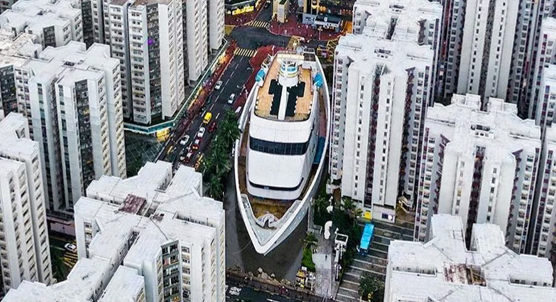
Credit: Reddit
You’d think a giant cruise ship was parked between buildings, but it’s actually a shopping mall shaped like a ship. The Whampoa was built on the site of a former dockyard, and the boat design honors its history. It’s filled with shops, restaurants, and yes, a food court inside the “hull.”
Russell Square – Bloomsbury, London, United Kingdom
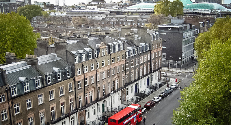
Credit: flickr
Looking at it from street level, it’s just another green park surrounded by Georgian buildings. But from the sky, Russell Square’s near-perfect symmetry pops out, grassy rectangles and a central fountain all arranged like it was made with graph paper. The design dates back to 1804 and is still clearly visible today.
Coca-Cola Logo – 18.529211, -70.249941 (Arica, Arica y Parinacota, Chile)
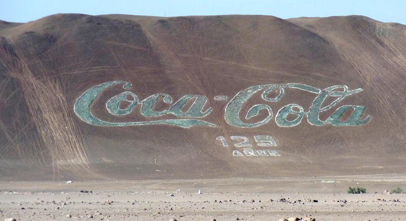
Credit: flickr
Etched into a hillside in northern Chile is a Coca-Cola logo made from over 70,000 empty bottles. It was created in 1986 to celebrate Coke’s 100th anniversary. At 130 meters wide, it’s still visible from space.
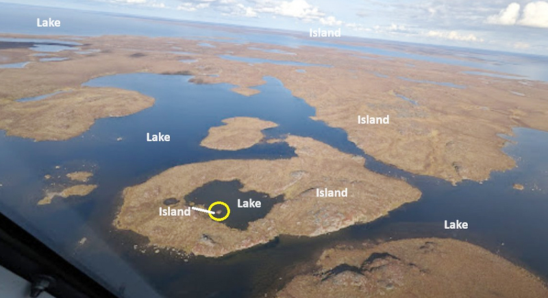
Island in a Lake in an Island in a Lake – 69.793° N, 108.241° W (Northern Canada)
Credit: X
This spot in Nunavut holds a tongue-twisting record: it’s a tiny island in a lake on an island in a lake on an island. Spotted by satellite, it’s considered the largest of its kind anywhere. It’s so remote, no one is known to have ever stood on it.
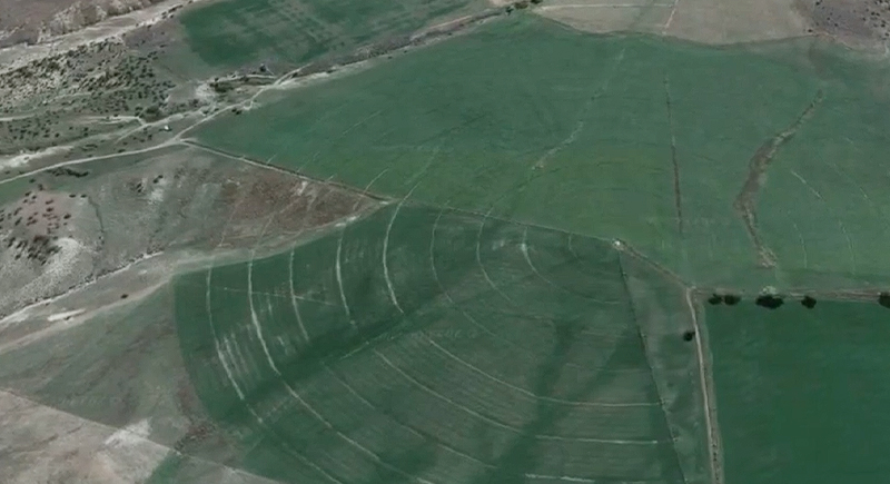
Concentric Circles – 39.623119, -107.635353 (New Castle, Colorado, USA)
Credit: Youtube
A field near New Castle looks like it’s been hit with giant crop circles. But these concentric rings are from center-pivot irrigation systems. The circles show different crop growth stages, and the overlapping areas make patterns that look way more alien than agricultural at first glance.
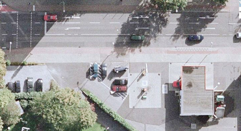
Flipped Car – 51°19’18.13″N, 6°34’35.64″E (Krefeld, Germany)
Credit: Facebook
Zooming in on a quiet parking lot in Krefeld, people were confused by what looked like a car flipped upside down. It turns out that it’s actually an art installation by a group called the Inges Idee collective. They embedded the vehicle nose-down into the pavement as part of a public art project.
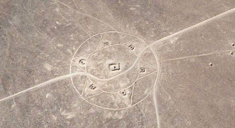
Strange Symbol – 37.401573, -116.867808 (Nevada, USA)
Credit: Facebook
This geometric shape near Area 51 sparked alien theories. The large circle with internal patterns is believed to be an aerial target, used for calibrating spy satellites and aircraft cameras. It sits in one of the most secretive regions in the U.S., which only fueled more conspiracy theories.
Monkey Face – 65.476721, -173.511416 (Russia)
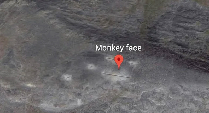
Credit: Reddit
In the Russian tundra, Google Earth users spotted what looks like a giant monkey face carved into the side of a cliff. It’s entirely natural (formed by weathering and shadow) but you can’t unsee it once you spot it. Some users call it the “Monkey King of Siberia.”
Big Swimming Pool – 52°29’52.24″N 13°27’13.67″E (Berlin, Germany)
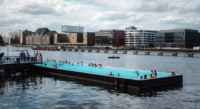
Credit: X
This massive swimming pool looks like it’s floating on the River Spree. It’s called “Badeschiff,” which means “bathing ship,” and has turned into a converted barge turned pool. Locals and tourists swim in it during summer while being surrounded by industrial views.
A Most Phallic Building – 41.84201, -89.485937 (Dixon, Illinois, USA)
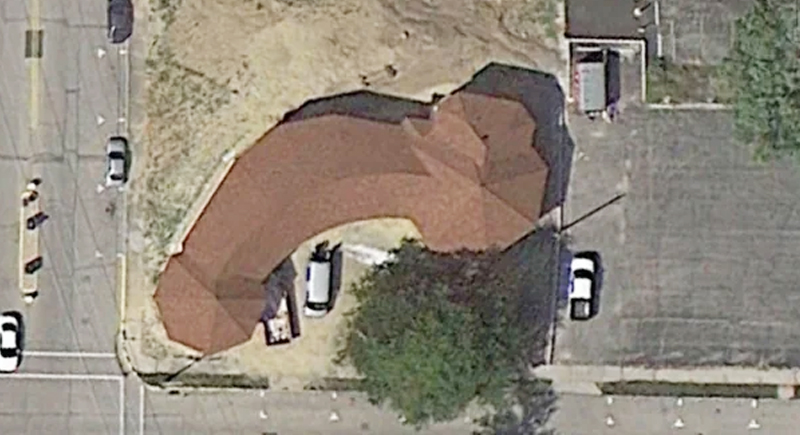
Credit: Reddit
The Dixon water tower caused a stir thanks to its unfortunately hilarious shape. From the ground it just looks like a regular municipal structure. But from a satellite angle, the shape and layout of nearby sidewalks make it look wildly inappropriate. Locals had a good laugh when it went viral.
The Badlands Guardian – 50°00’38.2” N 110°06’48.3” W (Medicine Hat, Alberta, Canada)
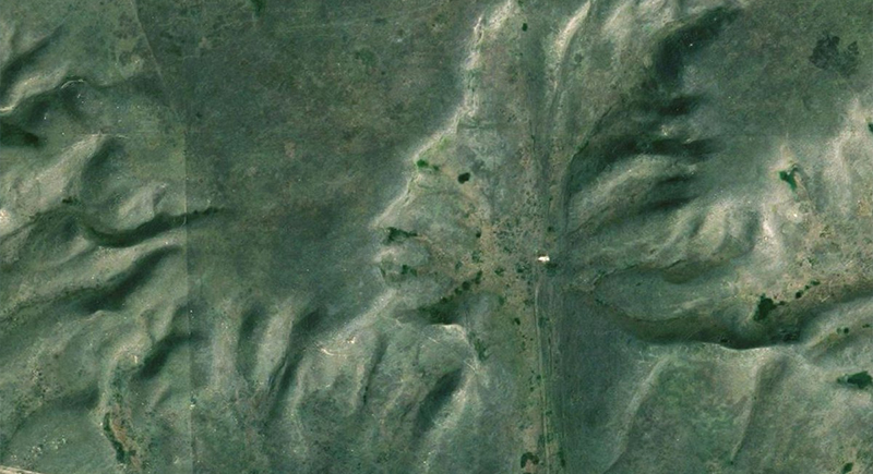
Credit: X
From high above Alberta’s badlands, the landscape looks like a giant human head wearing headphones. The shape formed through erosion, not human hands, which makes the image feel stranger once you notice the details. Google Earth users shared the coordinates for years before many people realized the “headphones” were actually a road and an oil well.
Giant Target – 33.35054, -111.45525 (Beatty, Nevada, USA)
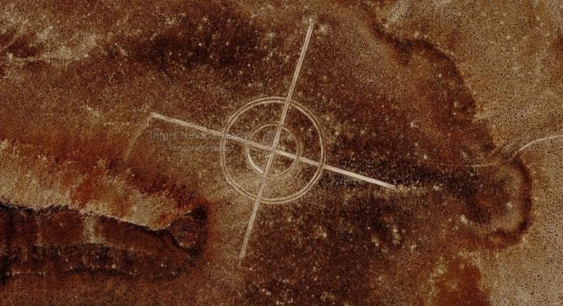
Credit: Reddit
Deep in the desert, Google Earth users spotted what appeared to be a giant bullseye painted on the ground. The circles stand out against the dirt so clearly that conspiracy theories spread before the real answer surfaced. It turned out to be an old bombing target linked to military training exercises, still visible from space decades later.